Swim Route vs. Swim Track
Sometimes basic principles need to be stated. This one is frequently confused, even by experienced open water swimmers.
A swim route is a predetermined, abstract path between the start and finish, composed of either a straight line or (if the straight-line path is interrupted by another land-mass) a series of connected straight-line segments.
For example, the route of an English Channel swim is the straight-line path between Dover, England and Cap Gris Nez, France (approximately 20.5 statute miles, typically rounded up to 21 by the CSA and CS&PF).
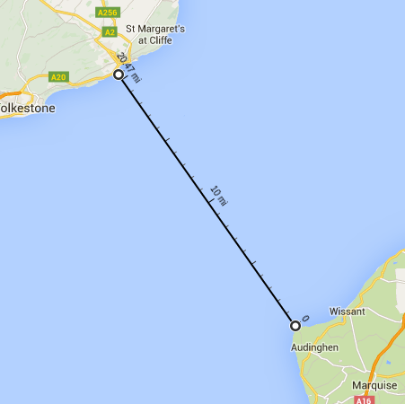
A swim route is typically the shortest path between the start and finish, though in some cases a longer path may make more sense (if certain characteristics of the shortest path make it undesirable, e.g., adverse currents).
In contrast, a swim track is where you actually swam - including navigation error, tidal movements, and other variables that cause differences between the abstract/ideal path and the actual path. A swim track is typically recorded with a GPS device.
For example, here is the track of a slower English Channel swim: The swimmer is first pushed southwest from Dover by the ebb tide, then northeast by the flood, then southwest by another ebb, then northeast by another flood and into the French coast.
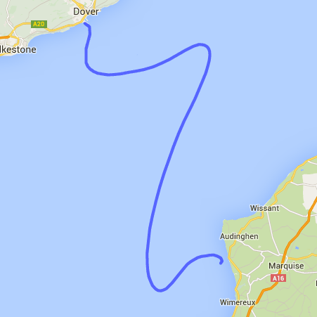
This swimmer obviously traveled much further than 20.5 statute miles - but that is irrelevant in measuring the distance of the swim! A one-way English Channel swim is 20.5 statute miles, regardless of whether the track is a big S-curve or a straight shot across like Trent Grimsey’s record swim. You don’t get to “take credit” for going off-route!
The distance of a marathon swim is the length of the route, not the length of the track.