Repeatable Swim Routes
Summary: Repeatable swim routes are defined by geography (permanent land features), and their measured distance is precisely consistent over time. Well-selected waypoints enforce a minimum route distance which cannot be shortcut. Enforced routes appear to “wrap around” points of land rather than “ricocheting” off them.
In planning new/unprecedented swim routes, it’s essential to understand (and frequently misunderstood) how to design the route so it is repeatable by future swimmers.
A route is repeatable if it is the shortest possible path that fulfills the route definition, with any intermediate waypoints defined by permanent land features.
- A repeatable route “enforces” a minimum distance because the route cannot be shortcut or “cheated.”
- Only natural routes (defined by permanent land features) are repeatable.
- Routes that include movable objects such as buoys may facilitate logistics and safety in mass-participation events. However, such “artificial” routes are unrepeatable and unsuitable for solo marathon swims.
A simple, straight-line route (Point A to Point B) is repeatable as long as the start and finish are well-defined, unambiguous locations.
For any route more complicated than a straight line, the swimmer must select appropriate intermediate waypoints that ensure an enforced, repeatable route. Sometimes waypoint selection isn’t obvious, so we’ll work through an example.
Case Study: Flathead Lake
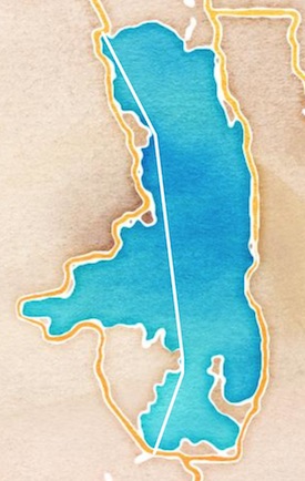
Flathead Lake, Montana is the largest lake (by surface area) in the western United States. The length of Flathead was first swum unassisted by Sarah Thomas and Craig Lenning in July 2015. They plotted a 44.5 km (27.6 mile) north-to-south route from Somers to Polson.
(Incidentally, both are MSF Documented Swims - see Sarah’s documentation and Craig’s documentation.)
In the map below, Sarah and Craig’s official route is shown as a solid white line. This is a repeatable, properly enforced route. It is the shortest possible swimming path between Somers and Polson. The path is defined by points of land which “block” the swimmer from a straight-line route (as a bird would fly).
An alternative route is shown as a dashed red line. This route is unrepeatable and unenforced. Notice how the red route isn’t constrained by any land features: It almost appears to ricochet or “ping-pong” off the edge of the lake. A ping-pong style route can be shortcut simply by turning earlier, before the waypoint is reached. The land doesn’t enforce the route.

The enforced (white) route is a valid, repeatable marathon swim route. The unenforced (red) route is unrepeatable - how can you know the full route distance was actually swum?
Enforced vs. Unenforced Waypoints
Consider the following map — a zoomed-in view of “The Narrows” in the far south of Flathead Lake, between Black Point and Finley Point.

Notice how the enforced (white) route line “wraps around” Black Point as it changes bearing from SW to SE. The route line creates an angle less than 180 degrees with respect to this waypoint.
In contrast, the unenforced route line ping-pongs off Finley Point, creating an angle more than 180 degrees.
Another way to think about unenforced waypoints is that they are nonsensical given the swimmer’s destination. If you want to swim from Somers to Polson, then Finley Point is an unnecessary detour, extending the distance of the swim.
Another example, in the northern part of Flathead Lake:

The enforced route line wraps around Angel Point as it changes bearing from SE to South. A detour and “ping-pong” off Woods Bay Point would be unnecessary, and render the route unrepeatable.
In sum, a swim route is fully enforced if:
- the start and finish are well-defined, unambiguous locations
- each intermediate waypoint between the start and finish is enforced
Unenforced Routes in Practice
The following route was proposed a few years ago, for what the swimmer hoped to be an attempt at the world record for longest lake swim (the swim was unsuccessful).
Given what you now know about enforced and unenforced waypoints, what do you notice about this route?

That’s right — lots of “ping-pongs” and unenforced waypoints. Of the 21 waypoints between the start and finish at Point A/K/W, by my count more than half are unenforced (C, F, I, K, L, N, O, Q, R, S, and V). It’s a perfect example of an unenforced, unrepeatable, unmeasurable route.
In practical terms, this means the geography of the lake cannot guarantee the claimed route distance of 105 km is swum. The route can easily be shortcut, and the actual distance would depend how closely the swimmer passed by each unenforced waypoint.
How can a swim be a world record if we can’t reliably measure the distance? Answer: it can’t. Some bodies of water may not be appropriate venues for world record attempts.
Anyway, it’s a moot point now. The Longest Lake Swim record is now held by Sarah Thomas - a 168 km island loop route (repeatable, measurable, enforced) in Lake Champlain.
Special Cases & Considerations
- A channel swim is an inherently enforced, repeatable route. The route distance is simply the minimum distance between the two land masses.
- A multi-way swim (e.g., double English Channel) is enforced only if the swimmer clears the water (or touches land above the water) after each leg. This is the only way to “prove” the leg was completed.
- A perimeter swim (e.g., swimming around the edge of a lake) is inherently unrepeatable - there is no reliable way to enforce how “tight” of a perimeter is swum.